Sale on canvas prints! Use code ABCXYZ at checkout for a special discount!

Boundary: Bleed area may not be visible.


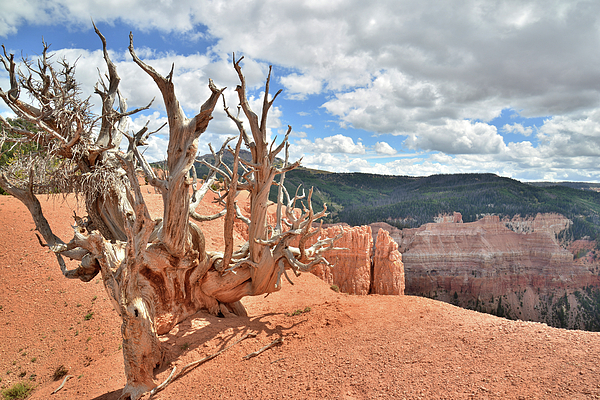
by Ray Mathis
$23.50
Size
Image Size
Product Details
Purchase a tote bag featuring the photograph "On the Edge #6" by Ray Mathis. Our tote bags are made from soft, durable, poly-poplin fabric and include a 1" black strap for easy carrying on your shoulder. All seams are double-stitched for added durability. Each tote bag is machine-washable in cold water and is printed on both sides using the same image.
Ships Within
2 - 3 business days
I started out shooting the "old fashioned way" with a 4x5" field camera and by creating color transparencies. I then scanned them at either 1200 or 2400 dpi. Every effort is made to match the original transparency. That said, there was a time when I developed cataracts, and scanning and preparing images for this website became difficult. Now that I've had surgery and can see clearly again, some of the images seem a bit too saturated in color. That's because cataracts mute colors. It's like looking through window covered with a film of grime and dirt. The challenge and reward in 4x5" landscape photography is to capture things as they really are, and get the exposure just right. And at over $6 a shot, it pays to be very selective. ...
$23.50


Ray Mathis
No problem. Glad to share. As you can see from the gallery, lots of possibilities. You just drive north from Cedar Breaks to Brian head. As you pass the actual Brian Head and drop down into the town on a big curve, at the end of this downhill curve, there will be a gravel dirt road on the left with a sign that says "Sugar Mountain" with an arrow. Follow that road for about 3 miles or so. At one point, it drops down to a junction with another road that goes off to the right. That's another way to come up. Go left or a short distance, maybe 1/3 of a mile, and there's a sign "Twisted Forest" on the left. The dirt road heads to something like a parking lot. It's a tear drop road. The Bristlecones are a short walk south from the parking lot. There's a trail (sort of) that goes up the first of three hills. It's like three fingers, and you start at the tip of one. Once up high, you can traverse across the rim to access the other two fingers.Or, rather than go up the first hill, you can continue S/SW and walk to the tips of the other two fingers. Some of my favorite trees are along the trail to the top of the first hill. There are some nice specimens along the rim too, with nice views of Cedar Breaks to the SE. The south face of the second hill has some nice specimens too, from top to bottom. A few of my favorite images have also come from the south face of the third hill, even thought there are not as many nice specimens there. Enjoy. It takes a while for the snow to melt out up there, and then the roads can be pretty muddy until they grade them.
Bob Christopher
Hi Ray...I like your image. Thanks for giving me a "heads up" on this area. I have photographed the Bristle Cone Pines in California but was unaware of these. Nice work...Cheers Bob fv